 +919871148514
 info@memorableindia.com
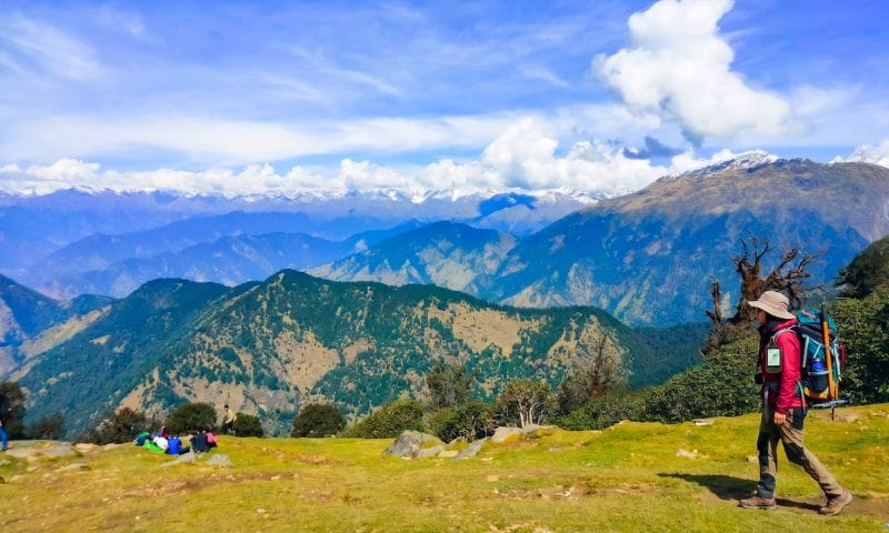
The Garhwal Himalayas carry a certain kind of quiet that most travel maps skip over. Ask anyone about trekking in Uttarakhand and the same names surface every time: Valley of Flowers, Kedarkantha, Roopkund, Har Ki Dun. Beautiful, no doubt, but crowded enough that solitude has become a rare currency on those trails. What rarely gets talked about are the routes tucked behind these headline names, trails that Garhwali villagers have walked for centuries and outsiders have largely left alone.
This is a working list for trekkers who want the Garhwal Himalayan region on its own terms: alpine meadows without queues, glacier snouts without selfie sticks, and shepherd trails that still smell of woodsmoke. Ten routes, each moderately to seriously demanding, each backed by real regional logistics rather than social media hype. Pick one according to fitness, time in hand, and an honest tolerance for remoteness.
The Garhwal ranges cover the western half of Uttarakhand and hold some of India’s most sacred peaks along with the headwaters of the Ganga, Yamuna, and Alaknanda. Well-known routes bring good infrastructure but also foot traffic that thins the wilderness experience. Offbeat trails give you three things that popular circuits cannot match: room to breathe, a genuine look at high-altitude Garhwali culture in villages like Ghuttu, Jakhol, and Sagar, and a natural environment that has not been trampled into dust.
According to the Uttarakhand Tourism Development Board, the state hosts more than a hundred documented trekking trails, most of which sit outside the mainstream circuit. That gap is precisely where the following ten routes live.
Bali Pass sits at roughly 4,950 metres, cutting across the Yamuna and Tons river valleys. The route begins from Sankri, the same base as Har Ki Dun, but branches off toward Ruinsara Tal, a startling emerald lake, before climbing over the pass and descending to Yamunotri. That final stretch is where the trek earns its reputation, a steep and exposed traverse that demands solid mountaineering awareness.
Best window is mid-May to June and September to mid-October. Duration runs 7 to 9 days, and the difficulty is genuinely tough, not a beginner’s playground. What makes Bali Pass special is the crossover: few Garhwal treks connect two distinct river systems on foot, and fewer still end at a Char Dham shrine. If you have already done Har Ki Dun and want the harder cousin, this is the natural next step.
Rudranath is the fourth shrine in the Panch Kedar circuit and the toughest to reach on foot. The temple sits inside a rock cave at about 3,600 metres, surrounded by alpine meadows called Panar Bugyal and Pitradhar. The trail from Sagar village near Gopeshwar climbs through dense oak and rhododendron forests, opening onto ridges that offer close-range views of Nanda Devi, Trishul, and Nanda Ghunti.
Duration runs 4 to 5 days, best attempted between May and October. Monsoon months are slippery and best avoided. The trek combines physical demand with cultural depth; the meadows here are grazed by Garhwali shepherds who still follow migratory routes their families have walked for generations. Combining it with a broader Panch Kedar Yatra itinerary turns a single trek into a spiritually rich circuit.
Madmaheshwar, the second Kedar in the Panch Kedar sequence, sits at 3,289 metres in the Mansoona valley. The trek begins at Ransi village near Ukhimath and covers roughly 16 kilometres through terraced fields, dense forests, and open ridges before reaching the temple. Compared to Kedarnath, foot traffic here is a fraction, and simple homestays in Gaundhar and Bantoli give you a genuine slice of Garhwali village life.
Duration is comfortable at 3 to 4 days, and May to June along with September to October offer the clearest weather. Bhuda Madmaheshwar, a smaller shrine two hours above the main temple, adds a moderate acclimatisation walk with sweeping views of Chaukhamba. This is a strong pick for first-time offbeat trekkers who want depth without extreme altitude.
Khatling is the lateral glacier that feeds the Bhilangna river, one of the main tributaries of the Bhagirathi. The trek starts from Ghuttu village in Tehri Garhwal and traces the river upstream for about 46 kilometres through Kalyani, Reeh, and Bhelbagi. The glacier snout at roughly 3,800 metres is ringed by peaks like Jogin, Sphetic Pristwar, and Thalay Sagar.
The route runs 6 to 7 days, best attempted between May and October barring peak monsoon. Difficulty is moderate to challenging, mainly due to remoteness and unpredictable weather. Khatling rewards patience with true isolation. You are unlikely to meet another group most days, and forest camps beside the Bhilangna have a quality of stillness that busier trails simply cannot offer.
Kush Kalyan is a rolling meadow system above the Bhilangna valley, sitting between 3,300 and 3,700 metres. Access is from Belak village, and the route climbs through mixed forests before opening onto grasslands that stretch for kilometres. On clear days the panorama covers Bandarpoonch, the Gangotri group, and the Kedarnath massif in one continuous sweep.
Duration is short at 4 to 5 days, and difficulty ranges from easy to moderate, which makes it a strong choice for fit beginners looking for a low-crowd introduction to Garhwal high country. Best done May through June and September through mid-November. Autumn afternoons here carry a golden light that photographers speak about but rarely capture in full. Local shepherds still bring their herds up in summer, keeping the pastoral rhythm intact.
Bagini is one of the lesser-visited glaciers in the Nanda Devi biosphere. The trek starts from Jumma village beyond Joshimath, passing through Ruing and Dronagiri hamlets before reaching Bagini base camp at around 4,500 metres. From there, an early-morning walk brings you close to the glacier snout with a direct line of sight to Changbang, Kalanka, and Dunagiri.
The trek runs 7 to 8 days, is moderately difficult, and has a short season: mid-May to June and September to early October. Because it borders the Nanda Devi National Park zone, forest department permissions apply, and groups are kept small by design. The last two camps are among the most photogenic in Garhwal.
Kedartal, or Shiva’s Lake, sits at 4,750 metres above Gangotri, a glacial tarn cupped between Thalay Sagar and Bhrigupanth peaks. The trail from Gangotri is only 18 kilometres one way, but it is famously demanding: loose scree, exposed ridges, and steep gains that make altitude sickness a real risk if pacing is off.
Duration is 5 to 6 days, best attempted between mid-May and June, then September to mid-October. This is a difficult trek reserved for experienced trekkers with prior high-altitude exposure. The reward at Kedartal is the sheer geometry of Thalay Sagar reflected on still water at first light, an image that regulars will tell you is worth every ache of the climb.
Panwali Kantha is an old pilgrim route connecting Ghuttu to Triyuginarayan, once used by devotees walking from Gangotri to Kedarnath. It crosses expansive meadows at around 3,600 metres with views of Chaukhamba, Sumeru, and Jogin.
Duration is 5 to 6 days at moderate difficulty. Best season is May through June and September through October. The route retains a very old feel: stone shepherd huts, wild strawberries in July, and virtually no tourist infrastructure. Villages along the base offer basic homestays where meals are simple mandua roti, kafuli, and jhangore ki kheer.
Borasu Pass at 5,450 metres connects the Har Ki Dun valley in Uttarakhand to Chitkul in Kinnaur, Himachal Pradesh. The trek is genuinely tough, involving glacier crossings, roped sections, and an unrelenting ascent from Ruinsara Tal onwards.
Duration is 9 to 10 days, best attempted only in June and September. This route is suitable for trekkers with prior high-altitude experience and basic mountaineering skills. Borasu is a route with historic weight; locals of both states have used it as a trade and marriage corridor for centuries. Walking across the pass and dropping into a completely different cultural zone within a week is the kind of experience that lingers long after the boots come off.
Sahastra Tal, literally the thousand lakes, refers to a cluster of glacial ponds at 4,400 metres above the Bhilangna valley. Access from Malla village goes through the Kush Kalyan meadows before climbing to the lake system. Weather here changes quickly, and the last two days require careful route-finding.
Duration is 7 to 8 days at moderate to difficult grade. Best window is late May to June and September. Very few operators run this route, which is exactly why it stays clean and quiet. On a good day you can see the Gangotri group, Jogin, Sri Kailash, and Kedar Dome in one panoramic sweep. It rounds off any list of the best offbeat treks in Garhwal region with the kind of finish that feels earned.
For a fully supported plan across any of these routes, our customised Himalayan trekking packages can be tailored around your dates, group size, and fitness. Share a rough window with our team through Contact Us and a Uttarakhand specialist will revert within 24 hours.
The Garhwal Himalayan region rewards trekkers who look beyond the obvious. These ten trails carry their own weather, culture, and difficulty grades. Some are demanding enough that they should not be attempted casually. But every one of them offers what popular trails no longer can: quiet camps, unclouded views, and a genuine encounter with the mountain communities who make Garhwal what it is. Choose carefully, prepare honestly, and the Himalayas will hold up their end of the bargain.
Khatling Glacier and Sahastra Tal consistently rank among the least crowded treks in the Garhwal Himalayas. Both routes see very few groups each season because of their remoteness, minimal infrastructure, and the technical care they demand. Trekkers looking for genuine solitude in the Garhwal Himalayan region often choose these two over the mainstream circuits.
Most offbeat Garhwal treks are safer with a small guided group rather than solo. Trails like Kedartal, Borasu Pass, and Bali Pass involve technical sections, unpredictable weather, and limited mobile connectivity. A local Garhwali guide is strongly recommended for route-finding, permits, and emergency response.
The best time for offbeat treks in Garhwal is mid-May to June for meadow blooms and stable weather, then September to mid-October for clear post-monsoon views. Monsoon months of July and August bring landslides and slippery trails. Winter routes exist but should only be attempted by experienced trekkers with snow gear.
Kush Kalyan Bugyal and Madmaheshwar are the two most beginner-friendly options among lesser known Garhwal trekking trails. Both offer meadow landscapes, modest altitude gains under 3,700 metres, and short durations of 3 to 5 days. They give first-timers a taste of Garhwal without the technical demands of glacier or pass crossings.
Yes, several offbeat treks in Garhwal require permits, especially those that cross protected areas. Bali Pass and Borasu Pass need Govind Pashu Vihar permits from Sankri; Bagini Glacier requires clearance for the Nanda Devi Biosphere buffer zone. Permits are usually arranged by tour operators, but self-organised trekkers should apply at least a week in advance.
Bali Pass Trek is significantly harder than Har Ki Dun. While Har Ki Dun is a moderate valley walk, Bali Pass involves an exposed high-altitude crossing at 4,950 metres, glacier sections, and a steep descent to Yamunotri. It is best attempted only after prior high-altitude experience, ideally with a route like Kuari Pass or Roopkund already completed.
Best Time to Visit Tadoba National Park, Maharashtra: A Season-by-Season Guide
09 Jul 2026
12 Jyotirlingas of Lord Shiva in India and Their Mythological Importance in Hindu Religion
08 Jul 2026
10 Romantic Retreats in Bhutan: The Perfect Honeymoon Spot
07 Jul 2026
10 Most Popular Festivals in Arunachal Pradesh You Should Plan Your Trip Around
06 Jul 2026
10 Most Beautiful Villages in Uttarakhand You Must Visit
05 Jul 2026


